REGULATION (EU) No 913/2010 OF THE EUROPEAN PARLIAMENT AND OF THE COUNCIL
of 22 September 2010 concerning a European rail network for competitive freight defines nine "initial freight corridors", of which number 6 is "Almería - Valencia/Madrid - Zaragoza/Barcelona - Marseille - Lyon - Turin - Milan - Verona - Padua/Venice - Trieste/Koper - Ljubljana - Budapest - Zahony (Hungarian-Ukrainian border)". It is due to be functional by 10 November of this year (2013).
Within Spain the apparent confusion caused by the obliques strokes is clarified, to some extent, in a footnote:
"‘/’ means alternative routes. In line with the TEN-T priority projects, routes 4 and 6 should in the future be completed by Project 16, the Sines/Algeciras-Madrid-Paris freight axis which takes in the central Pyrenees crossing via a low elevation tunnel."
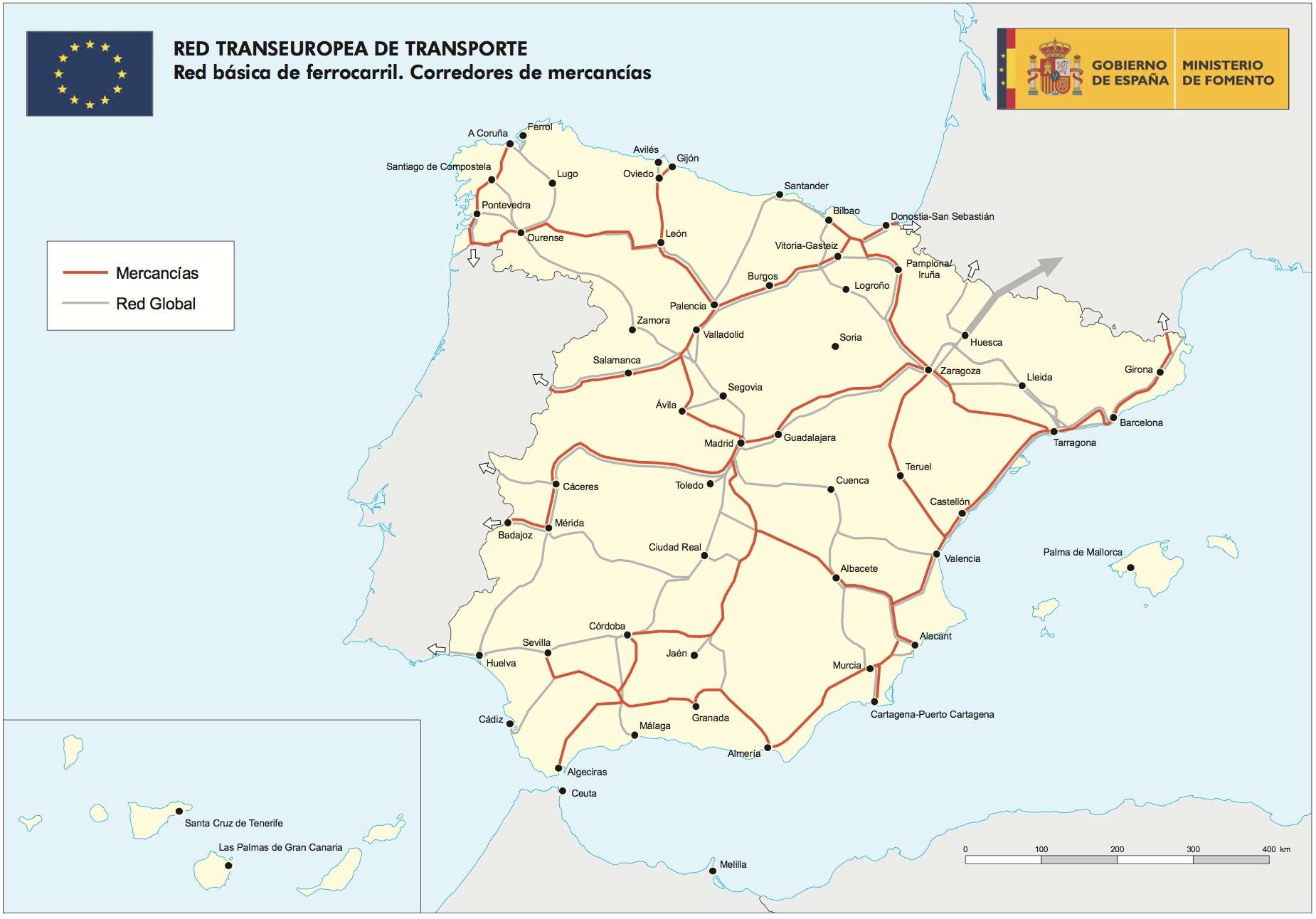
This map, shows the (planned) main routes from the Iberian peninsula into western Europe and helps to clear the confusion. There are others you can refer to here.
"Almería - Valencia/Madrid - Zaragoza/Barcelona - Marseille" presumably means that the plan includes two European gauge rail freight corridors:
a. Almería - Madrid - Zaragoza - Marseille...
b. Almería - Valencia - Barcelona - Marseille...
The latter is the "Mediterranean corridor", long-demanded by all the Mediteranean ports, whose geostrategic position would allow them (and thus the peninsula as a whole) to compete with the ports of northern Europe (Antwerp, Hamburg, Tilbury...) for the lucrative Middle and Far Eastern trade market.
The oblique strokes would seemingly not make clear how the Zaragoza - Marseille connection is to be made. A quick look at the map of "initial freight corridors" suggests that the Barcelona route makes economic sense, without the need for investments beyond.
However, the map certainly does not clarify the Almería - Madrid route: one stretch of the track is not marked for freight.
Moreover, the footnote says that "routes 4 and 6 should in the future be completed by Project 16, the Sines/Algeciras-Madrid-Paris freight axis which takes in the central Pyrenees crossing via a low elevation tunnel". What is Route 4? Route 4 starts in Sines (Portugal) and takes two routes, - Lisbon/Leixões and - Elvas/Algeciras before linking up, on both routes, to Madrid - Medina del Campo/Bilbao/San Sebastian - Irun - Bordeaux - Paris/Le Havre/Metz.
What is Priority Project 16", then? It seems to be a longer term project, one of "30 Priority Projects (or axes)...
identified on the basis of proposals from the Member States and are
included in the Union guidelines for the development of the TEN-T as
projects of European interest" (source)
This is the map of the enigmatic "Priority Project 16: Freight railway axis Sines/Algeciras-Madrid-Paris", not included as one of the "initial freight corridors" in the 2010 Regulation.
As far as one can see, this is basically the initial freight corridor No. 4, up to Madrid. And from Saragossa northwards, we again find that enigmatic route through the Central Pyrenees, marked as a grey line in the top map, and here in a strange arrow shape.
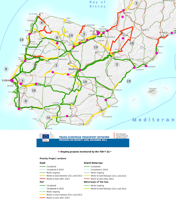
The Executive Agency's 2011 Progress Report on on-going projects (the most recent I have found) consists of a map, of which I have just taken the following:
Yet again, there is an enigmatic, but well drawn arrow shape or through across the central Pyrtenees. Moreover, the pink dot in the middle means that there is (or was) an on-going project in that area. WEhat is it? Well ,the previous map gave its reference number, which corresponds to "Freight Railway Axis Sines-Madrid-Paris: New high capacity line through the Pyrenees". We are informed on the Agency website that
"At a high level inter-governmental conference in Zaragoza, Spain in
June 2008, France and Spain committed to launch the necessary studies
for the construction of this new line through the creation of a European
Economic Interest Group (EEIG).
This project specifically consists of the preparation of the following studies as:
- Preliminary technical, economic and financial studies, including an
analysis of the possible locations of the corridor in France and Spain
- Environmental studies
- Studies necessary to launch the public consultations in Spain and the public debate in France"
The Agency website tells us that "The project also includes the construction of a long distance tunnel
through the Pyrenees, in order to eventually link it with the branch of
the Grand Projet du Sud-Ouest [GPSO] towards Toulouse." However, the GPSO website speaks nowhere at all of any tunnel through the Pyrenees. Instead it says that "Le Grand Projet ferroviaire du Sud-Ouest fait partie du projet global
LGV Sud Europe Atlantique (LGV SEA) défini, depuis la déclaration
d'intention du 25 janvier 2007, comme un ensemble cohérent composé de
trois branches : Tours-Bordeaux, Bordeaux-Toulouse et Bordeaux-Espagne,
auquel a été ajoutée la branche Poitiers-Limoges."
Returning to the Agency website, we read that Priority Project 6 is the "Railway axis Lyon-Trieste-Divača/Koper-Divača-Ljubljana-Budapest-Ukrainian border" does not start in Almería or even in Spain: it takes off in Lyon.
The confusion grows when we read yesterday that
"Pastor firma en Bruselas un acuerdo que impulsará el transporte ferroviario de mercancías por el Corredor Mediterráneo
Con los responsables de transportes de Francia, Italia, Eslovenia y Hungría.
- El acuerdo
establece la Comisión Ejecutiva del Corredor Ferroviario de Mercancías
nº6, que se extenderá desde Almería hasta Zahony (Hungría)."
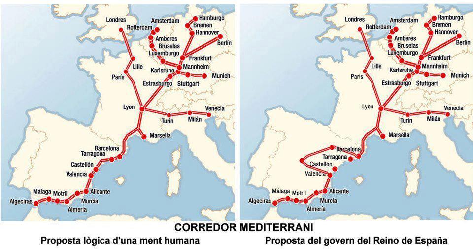
Today twitter is full of odd maps (like the one on the right, below) and many Catalans feel that the "Mediteranean" corridor Minister Pastor speaks of will in fact go through Madrid! A public clarification is in order!


